- Home
- Telematics
- What is geofencing and how does it work?
What is geofencing and how does it work?
What is geofencing?
How does a geofence work?
What is the purpose of geofencing?

What is geofencing?
So, what are geofences? In general, it is a technology which utilises GPS or RFID to create virtual boundaries around specific geographic areas, known as geofence areas. When a vehicle enters or exits these predefined areas, the geofencing system triggers alerts or actions.
That means with geofencing vehicle tracking, it helps to monitor your company’s vehicle locations and ensures they remain within designated areas or routes. This enhances security, compliance with route regulations, fleet management control, and more.
How does a geofence work?
A geofence works by establishing virtual boundaries using GPS coordinates. When a vehicle – equipped with an applicable geofence tracking device – crosses these boundaries, the asset tracking system detects the movement and triggers predefined actions or alerts.
How does geofencing work in terms of boundaries? The geofence can be customised to cover specific locations such as job sites or restricted zones. The tracking software then continuously monitors the vehicle’s position in real-time, delivering accurate, prompt detection of any boundary crossings.

Benefits of geofencing in vehicle tracking
Enhanced security
With vehicle geofencing, you can closely monitor asset locations and receive alerts for unexpected movements. This helps prevent unauthorised use and theft of company vehicles.
Route compliance
You can track to make sure vehicle drivers adhere to designated routes. Along with improving compliance, this reduces deviations and enhances route optimisation.
Operational efficiency
As you track vehicle movements in real-time, it’s possible to optimise fleet operations by monitoring the best routes and reducing unauthorised stops.
Improved customer service
With geofencing and the ability to monitor vehicles in real-time, you’re in a better position to provide accurate delivery times and improve delivery performance.
Cost savings
Along with optimising routes, you can reduce fuel and maintenance costs – and ultimately save money – by preventing unauthorised usage.
Timely maintenance
Receive alerts when vehicles enter maintenance areas. These alerts ensure timely servicing and a reduction in downtime.
What is the purpose of geofencing?
With vehicle tracking, the purpose of geofencing is to enhance fleet management by gaining precise location monitoring and control.
When people learn what does geofencing mean, their minds often turn to its most clear benefit: enhanced security. It helps prevent unauthorised vehicle use by allowing businesses to respond promptly to any deviations or unauthorised activities.
Yet that’s not all. With these virtual boundaries, your company can optimise fleet performance, reduce costs, improve customer service, and more.

How accurate is geofencing?
Various aspects influence the accuracy of geofencing. These aspects include the GPS technology's quality and the defined boundaries' precision. Additionally, factors like satellite signal strength, environmental conditions, and the quality of the tracking device can all play a part.
At Radius, we have invested in modern GPS systems which deliver high accuracy within just a few metres. Our innovative Kinesis system allows for easy, well-defined geofence areas, while our robust trackers are built with quality at the forefront. The result: highly accurate geofencing.
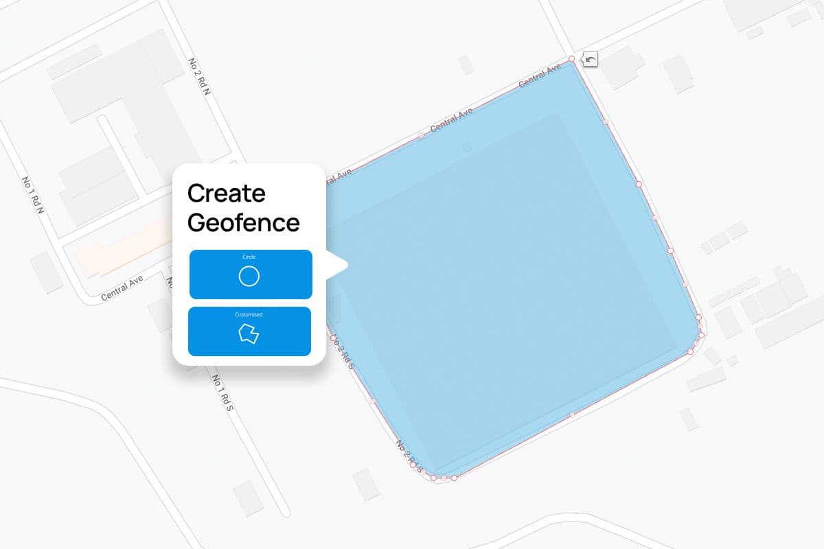
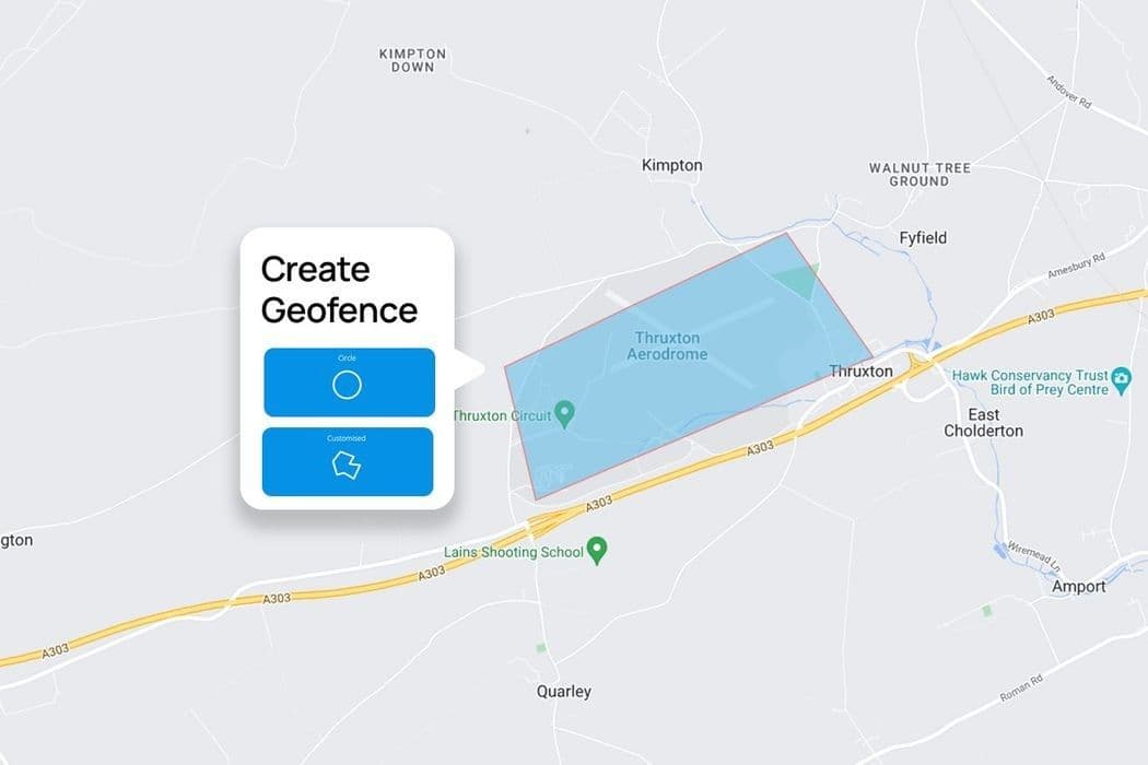
How to create a geofence
When learning how to geofence a location, this involves defining a virtual boundary using GPS coordinates. With our web-based Kinesis software, this task is an effortless one.
After clicking “Create Geofences”, select either “Circle” or “Customised” for the geofence parameters. Then input your location. You’ll then be presented with a map view where you can accurately set the geofence. This can also be moved, via drag-and-drop, to precisely match your requirements. Once saved, our system will begin monitoring vehicle movements within the defined geofence.
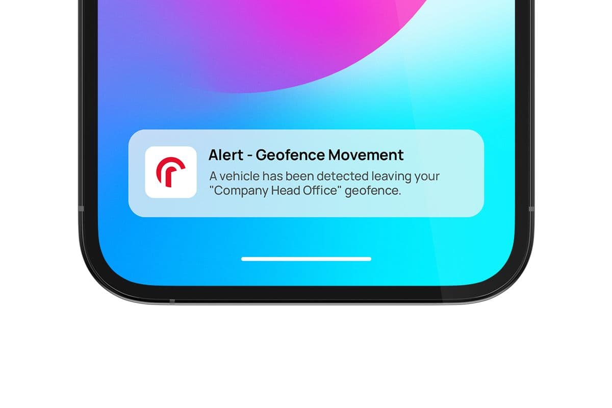
What are geofence alerts?
Explaining what is a geofencing alert and how it works.
Geofence alerts are notifications triggered when a vehicle enters or exits a predefined geofence area. These alerts can be customised to meet specific needs – whether it’s unauthorised movement, route compliance, or maintenance requirements.
Alerts are sent in real-time via our vehicle tracking software, email, or SMS. This allows for immediate response to keep your vehicles safe and optimised.
Frequently asked questions
Can’t find an answer to your question? Talk to the Radius customer support team on 00353 91 482 943. We’re here to help you with any questions or concerns you may have.
How much does geofencing cost?
How effective is geofencing?
Is geofencing worth it?
Is geofencing legal?
Partnership
Why choose Radius?
With innovative solutions built around the needs of our customers, we've established an international reputation for helping businesses grow sustainably.
Expertise
Our team has over 34 years of experience helping more than 400,000 customers globally.
Trust
We are an internationally-acclaimed provider with numerous awards for our products and services.
Choice
Choose from our range of fleet, mobility and connectivity solutions that can be tailored to suit your needs.
Solutions
Use our award-winning technology and services to save your business time and money.


Need help?
Can’t find what you are looking for?
The customer support team at Radius Ireland provides an Island of Ireland service with four offices in Northern Ireland and four in the Republic of Ireland to best serve our clients' needs.
Contact us